
Types of Open Space
Urban open spaces come in a wide variety of types: it can include greenspace, blue space (water), brown space (brownfield land) and grey space (hard surfaced areas). As a result, it can often be difficult to define its scope. In 1869 a Russian chemist, Dmitri Ivanovich Mendeleyev (1834-1907), devised the Periodic Table of elements that improved understanding by sorting information in a structured way. The infographic below uses the table as a template for illustrating the different types of open space found in urban, suburban and peri-urban (urban fringe) areas.
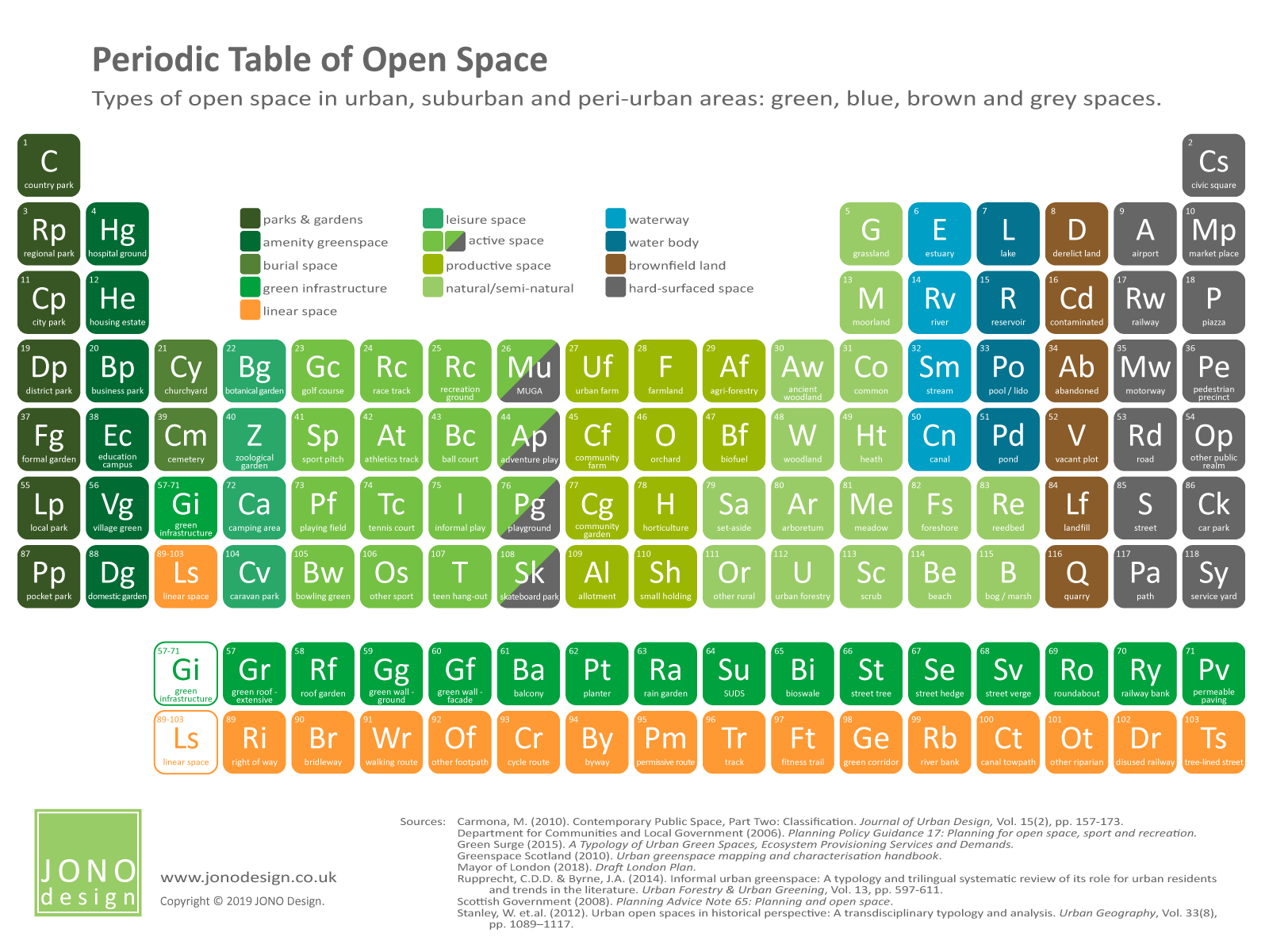
Click on the infographic to enlarge it.
The Periodic Table
Mendeleyev’s 1869 table arranged metal and non-metal elements according to their atomic numbers, adding a systematic structure to the information. The table of elements that Mendeleyev first drew 150 years ago has grown with the discovery and creation of new elements and is still in use today.
The design and layout of the Periodic Table is of a recognisable form and shape. The grid-like diagram has been used as a template many times to display a wide range of different information, making the data appealing as it is structured in a familiar way.
Types of urban open space
Using the Periodic Table as a template for open space means that 118 different types can be represented, illustrating the diverse character of urban space. Each open space type in the infographic has been given a number, symbol letter(s), name and colour. Similar types of open space have been grouped together by colour and in columns. Unlike the original table, the numbers do not relate to the type of space and are only provided to help identify the different types of space.
The types of open space that have been included in the infographic are based on a broad definition that includes greenspace, blue space (water), brown space (transitional) and grey space (hard surfaced areas). The scope includes open space in urban areas, suburban areas and in the urban fringe (sometimes called peri-urban areas or the countryside in and around towns). The infographic does not illustrate the type of ownership or whether an open space is open to the public, like a park, or is private, like a domestic garden.
Greenspace includes parks, amenity spaces, residential gardens, burial grounds, outdoor facilities for sports and play, food growing areas, and natural and semi-natural areas. Active spaces are shown as green/grey spaces as these types of play and recreational facility can be a mix of soft and hard surfaces. Blue space incorporates open and running water, such as lakes, reservoirs, rivers and canals. Brown space, or brownfield land, consists of land that is in transition in some way, such as wasteland or derelict open land. Grey space includes open spaces that have hard and impermeable surfaces, such as civic squares, streets, car parks and other areas of public realm.
The greenspace shown also includes two sub-categories, ‘Gi’ Green Infrastructure (numbers 57-71 in the infographic) and ‘Ls’ Linear Space (numbers 89-103). While all greenspace functions as green infrastructure, the first sub-category contains elements that ‘green’ the buildings and hard surfaces of the urban area, such as green roofs, rain gardens and street trees. Many of these types introduce vegetated surfaces that are designed to reduce the risk of flooding by slowing the flow of water. Linear Space relates to green corridors and routes through the urban area, such as rights of way, riverside walks and cycle routes, which can go through and run between open spaces.
It should be kept in mind that open spaces are usually multi-functional. For example, a public park could also have play and sports facilities, as well as semi-natural areas of habitat. Therefore, the infographic only displays the primary use of the open space being described.
The green network
Together, greenspaces and blue spaces make up a green network in urban areas. The network, or matrix, includes all green and blue spaces regardless of ownership, public accessibility or contiguity. While the ‘Gi’ types relate to elements that are not located in open space, the ‘Ls’ elements can form part of an open space, and both types can also form links that connect open spaces as they go through the urban area. Thinking of urban open space as a network means that a strategic view of provision can be developed that recognises how spaces function together, thereby providing benefits to the urban area as a whole.
Sources
Carmona, M. (2010). Contemporary Public Space, Part Two: Classification. Journal of Urban Design, Vol. 15(2), pp. 157-173.
Department for Communities and Local Government (2006). Planning Policy Guidance 17: Planning for open space, sport and recreation.
Green Surge (2015). A Typology of Urban Green Spaces, Ecosystem Provisioning Services and Demands.
Greenspace Scotland (2010). Urban greenspace mapping and characterisation handbook.
Mayor of London (2018). Draft London Plan.
Rupprecht, C.D.D. & Byrne, J.A. (2014). Informal urban greenspace: A typology and trilingual systematic review of its role for urban residents and trends in the literature. Urban Forestry & Urban Greening, Vol. 13, pp. 597-611.
Scottish Government (2008). Planning Advice Note 65: Planning and open space.
Stanley, W. et.al. (2012). Urban open spaces in historical perspective: A transdisciplinary typology and analysis. Urban Geography, Vol. 33(8), pp. 1089–1117.
This infographic appeared in JONO Design e-news. The e-news is published once every couple of months and each issue contains a specially designed infographic.
Click on the orange button to sign up for JONO Design e-news.

Get in touch to discuss your design requirements
or to request a quote.
enquiries@jonodesign.co.uk
Copyright © 2015-2024 JONO Design.
Designing solutions with Word